Donnerstag, 27. Oktober 2011

Haiti - Port au Prince

Mapping the information
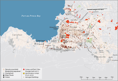
Grahic visualisation of different informations based on maps of charity institutions, various studies and text. Overlapping the individual layers, the different information can be compared and analyzed for dependencies.
 
Spontaneous camps (15.01.2010), long-term camps (Google Earth 2011) and hospitals
 

Spontaneous camps (15.01.2010), long-term camps (Google Earth 2011) and collapsed buildings
 

Camps and tent cities (Google Earth 2011), neighborhoods and industrial areas
 

Camps and tent cities (Google Earth 2011), power plants, international bases, damaged infrastructure and landslides
  

Camps and tent cities (Google Earth 2011), analysis of flood risk


Mittwoch, 26. Oktober 2011

quartzsite_arizona


- recessing informations about the city and it's camping areas
- overviev map
- comparing similarities of self forming structures with the phenomenon of the RV's organization in quartzsite
 - providing profiles of "the typical RV-owner" and his daily routine


Fukushima Refugees

We have been working on creating maps from the information that we had gathered for last week.  We remapped the maps that we had found from MapAction and then mapped data from other sources so that we could create comparisons between the number of people in evacuation shelters at different points in time.  These maps have also helped us to understand the movements of displaced people away from the Fukushima Prefecture and this movement is something that we looked at further when we created individual case studies of people who were forced to evacuate from their homes.


We also began to analyse the GoogleMaps data that we have so that we can have a greater understanding of the exact location, type and occupants in each Evacuation Centre after the disaster.

Refugee Camp in Kenya - Organisation

This week we kept ourselves busy with finding out how the camps are organised from two different points of view.
On the one hand we took a look at how the somali refugees moved from Mogadishu to Dadaab Refugee Camps and on the other hand how the camps are organised by the helping organisations like UNHCR or UNICEF.
To compare the three camps we filtered out the specific points such like food distribution. For this we made a map to show how the refugees are reaching that important point.
We also took a look at the structure of the three camps Hagadera, Ifo and Dagahaley, how were they built up by the system of the organisations and which parts of the camp are self-settlement.